 button to
add some content. There are two possibilities:
button to
add some content. There are two possibilities:Intermediate users
and above have access to the button to
add some content. There are two possibilities:
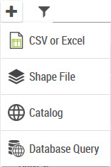
a CSV, Excel or SHP dataset:
One can choose an Excel or CSV file from the own system or from a resource on the network. When importing an Excel file type XLSX the size limit is 1MB.
Add a shapefile: it is also possible to import an SHP file from the local system. The SHP format being composed of several files, it is important to choose the file set of these files (.shp, .dbf, .prj, .cpg, .shx, .qix).
a layer from the catalog of geographic data:
The data contained in the layer will be imported.
Add data from a database from an SQL query (only the user having the “configSQL” role have access to this option.
|
The CSV / Excel / SHP import is available as an extension and the feature is controlled by the product license. |
|
The catalog represents the list of vector map services declared in the administration console. It also include the territory projects that have been published. |
|
One can copy/paste a Galigeo eXperience custom element, or a WebI document containing a custom element, however the imported datasets and the created territory management project will not be copied. |
The matrix bellow sums up all the possibilities for the rights:
User type |
Dataset privacy |
Is Owner |
Can View ? |
Is Editable ? |
End user |
Public |
|
YES |
NO |
End User |
Private |
|
NO |
NO |
Intermediate User |
Private |
YES |
OK |
OK |
Intermediate User |
Private |
NO |
NO |
OK |
Intermediate User |
Public |
NO |
YES |
NO |
Author / Designer |
Public |
YES |
YES |
YES |
Author / Designer |
Public |
NO |
YES |
YES |
Author / Designer |
Private |
YES |
YES |
YES |
Author / Designer |
Private |
NO |
NO |
NO |
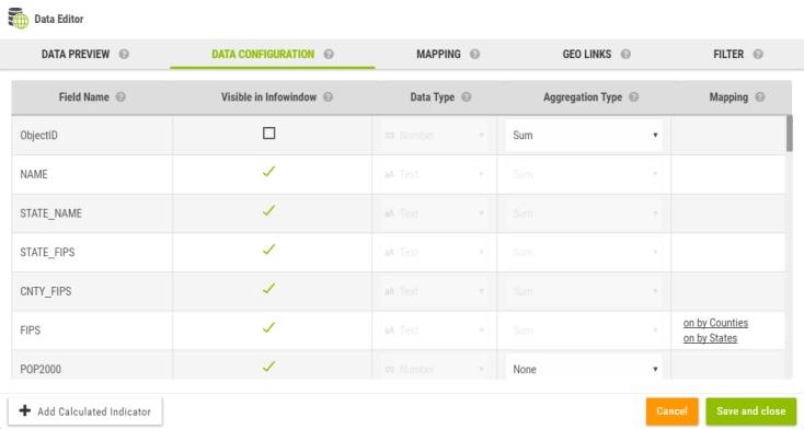
As soon as a data is imported, the data wizard is opened.
The
data wizard can be opened anytime later by clicking on  .
.


